

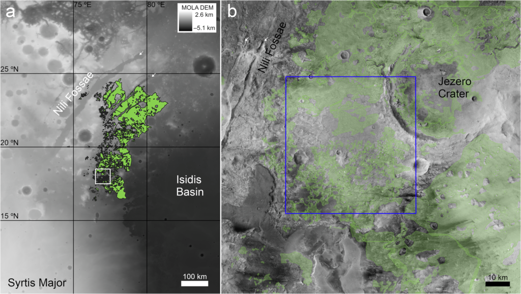
Geologists have argued for more than 20 years about how a vast sheet of green rock came to lie across the plains west of Jezero crater on Mars. Some saw volcanic ash that had settled out of the sky; others saw ancient dunes turned to stone. A new study of the Nili Fossae olivine unit argues that both camps had it the wrong way up. The rock did not fall onto the surface at all. It was pushed into the crust from below as molten magma, then dug out by billions of years of erosion.
The work, led by Michael Bramble of NASA’s Jet Propulsion Laboratory with colleagues at Brown University, Caltech and elsewhere, was published on 11 November 2026 in Communications Earth & Environment. Its target is the regional olivine unit, a carbonate-bearing layer rich in olivine, a green iron and magnesium silicate that crystallises early from hot, primitive magma. The unit sits on the north-western rim of the Isidis basin, an impact scar about 1,900 km across that formed roughly 3.96 billion years ago. Nili Fossae itself is a set of troughs hundreds of kilometres long, curving around Isidis like ripples around a dropped stone.
Perseverance made the puzzle sharper. On the floor and inner rim of Jezero, the rover found the olivine-rich rocks to be coarse grained, with crystals packed in a way that points to slow cooling inside a body of magma rather than to ash or windblown sand. From orbit, though, the same unit outside the crater seemed to drape over hills and hollows like a blanket, which is what airfall deposits do. Rover and orbiters were telling two different stories.
To settle the matter, the team mapped narrow, light-toned stripes known as Large Linear Features in Nili Planum, the plains just outside Jezero, using 48 HiRISE images from Mars Reconnaissance Orbiter. They counted 484. Each is tens to hundreds of metres wide and thousands of metres long, and some run straight for more than 15 km. Orbital spectra show the same olivine and carbonate as the regional unit. Their average orientation, 26.1 degrees east of north, matches the 25.2 degrees measured for nearby segments of the Nili Fossae troughs.
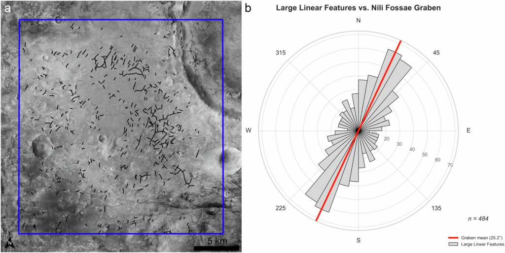
That alignment is the first clue. The second is the way the stripes meet. The authors record at least 121 sharp junctions, some splitting three ways at 120 degrees and others crossing at right angles: the geometry of magma forcing its way through crust already cracked in several directions. Many stripes are also edged by ridges a few metres high. On Earth, rims like these form where magma chills against cold rock or bakes its neighbour harder, so they outlast softer material. Wind carves parallel grooves in one direction. It does not make triple junctions.
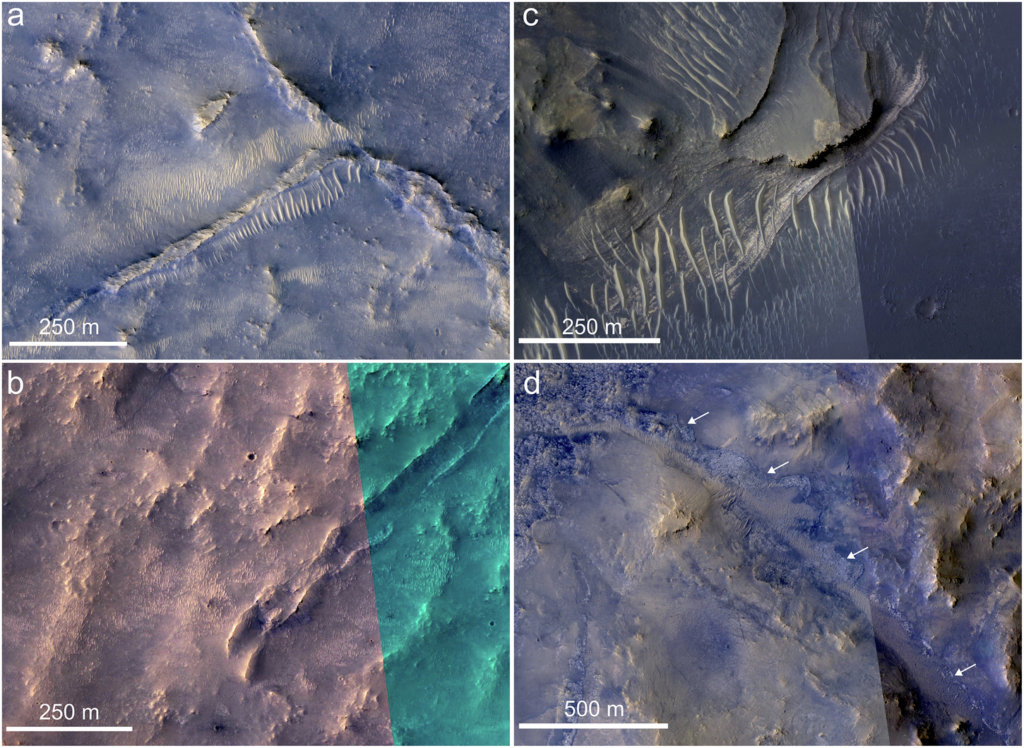
The draping problem gets an equally tidy answer. The team proposes that much of the unit was injected as saucer-shaped sills, flat sheets of magma that curl upwards at their edges, like those of South Africa’s Golden Valley Sill Complex. Strip away the softer rock around such a saucer, and its curved rim can look very like a layer laid over an existing bowl. Measured without the vertical exaggeration common in 3D renderings, the Martian unit is close to flat, dipping less than 5 degrees across tens of kilometres.
If the interpretation holds, the olivine rock outside Jezero, the Séítah formation on the crater floor and the Margin unit on its rim become parts of one plumbing system. The stripes point straight towards those rover sites, and some cut across Jezero’s rim, so the olivine unit must be younger than the crater. That reverses a long-standing assumption about the order of events at Perseverance’s landing site. It also weakens the unit as a dated marker layer: crater counts give its surface an age of about 3.82 billion years, but craters only collect once a rock is uncovered, so the intrusion is probably older.
Erosion on this scale is a claim in its own right. The authors place the sills less than about 1 km below the ancient surface, implying that hundreds of metres of weaker rock have since been stripped away. Jezero’s battered rim, which appears to have lost around 800 metres compared with fresh craters of its size, fits that picture. A related paper led by co-author Adomas Valantinas, in Earth and Planetary Science Letters, examines another candidate feeder system nearby.
All of this rests on pictures taken from orbit. The depth at which the magma settled and the amount of later erosion are both unknown, which leaves the unit’s true age loose, and the varied junction angles hint at several separate injections over a long period. Saucer-shaped sills are best known from sedimentary basins on Earth. That the shattered, impact-churned crust of early Mars behaved the same way is a proposal, not a demonstration.
Helpfully, the test sits within driving distance. Perseverance has climbed out of Jezero and is heading west into the older crust beyond. If the model is right, it should eventually find a chilled margin of fine-grained rock at the edge of the olivine unit, with a halo of heat-altered rock just beyond.
An argument conducted from orbit for two decades may end at a single rock face, where the cooled edge of an old magma sheet either is or is not there to be seen.
